


War Gaming In The Essequibo: A Deep Dive Into A Potential Venezuelan Invasion Of Guyana
This report analyzes the factors and potential scenarios of a Venezuelan invasion of Guyana, including the terrain, military forces, infrastructure, and much more.

Table Of Contents:
Preface
Approach
Timeframe
Scope
Limitations
Principal Findings
Historical Context
Current Situation
Social/Political Considerations
Economic Considerations
Civilian Considerations
Terrain
Weather
Infrastructure
Force Composition
Command and Control
Mission And Execution
Ground Campaign
Maritime Arena
Aerial Arena
Logistics
Scenarios (1-4)
Conclusion
Preface:
It is very unlikely that Venezuela will invade Guayana. There are a multitude of factors that will hamper any attempts at invasion. Firstly, Venezuela's military capabilities are weakened, with much of its equipment in disrepair. Despite having a larger military force compared to Guyana, Venezuela's economic crisis has degraded its ability to wage war effectively. The Venezuelan military suffers from low morale and is designed to respond to domestic threats more than offensive actions. Secondly, any attempt at invasion would face resistance not only from Guyana but also from allies who would come to Guyana's aid. Brazil, in particular, shares borders with both countries and has intensified defensive actions in the region. Additionally, invading Guyana could have serious diplomatic and geopolitical consequences for Venezuela. It could lead to even further isolation on the international stage and provoke strong condemnation from regional and global powers (including its closest allies such as China.) Furthermore, Venezuela's President Nicolás Maduro is facing domestic political challenges and is under pressure to hold free and fair elections. Invading Guyana could exacerbate these challenges and further undermine Maduro's legitimacy both domestically and internationally. The conflict with Guyana over Essequibo is more useful to Maduro as it stands now; a rallying call to distract the public from domestic issues.
This report is based on my opinions and individual analysis. I did not run any game statistics. I will be using Intelligence Community Directive 203 (ICD 203) when using terms referring to probability. All of the information I used in this report is based on open source information so take some of the numbers with a grain of salt.
Approach: This wargame utilized open-source data from a variety of sources and paired it with pre-established academic analysis (CSIS, Wilson Center, Georgetown University, and Independent OSINT analysts) and analysis done by the author (Sud Am News). The author did not run any gaming statistics. All terms of probability are based solely upon the judgment of the author. This war game report analyzed four potential scenarios.
Timeframe:
June-August 2024
Scope: This wargame focused on the events directly associated with potential amphibious operations, a potential ground campaign, and limited aerial operations within the Essequibo region of Guyana.
Limitations: The findings of this report are based upon the author’s analysis and judgment, which could be flawed. This report only analyzed four potential scenarios which is far from exhaustive.
Principal Findings:
The likelihood of a successful Venezuelan invasion of Essequibo is low due to potential resistance from Guyanese forces, international diplomatic pressure, and considerable logistical challenges.
Suriname may exploit the situation to assert its territorial claims, although the probability of direct military intervention remains remote.
A protracted conflict similar to Ukraine is more likely, with Venezuela annexing parts of Essequibo after a costly and prolonged campaign.
Guyanese forces have a remote but plausible chance of repelling the Venezuelan invasion, leading to significant political and military repercussions for Maduro and Venezuela.
A coalition-led operation is most likely, involving Brazil, the United States, the United Kingdom, and other regional allies to repel the Venezuelan invasion. This would result in significant military, economic, and diplomatic consequences for Venezuela.
Suriname may choose to either remain neutral, exert diplomatic pressure for a peaceful resolution, or join the international coalition, depending on the circumstances and regional dynamics.
Historical Context:
The border dispute between Venezuela and what is now Guyana dates back to the 19th century when the territory was under British control. The British colony of British Guiana had de facto control over the vast, densely jungled area west of the Essequibo River. However, Venezuela inherited the territorial claims of its former overlord, the Spanish Empire, claiming that the border was along the Essequibo River. Tensions arose when gold was discovered in the Essequibo region in the 1850s. In 1899, Venezuela and British Guiana came to a settlement, with mediation from the United States Of America and Russia. The Paris Arbitration Award ruled that Venezuela had sovereignty over the Orinoco River basin, while British Guiana’s sovereignty over the land between the Orinoco and Essequibo rivers was recognized. Today, that area represents almost two-thirds of Guyana’s national territory.
However, Venezuela challenged this ruling in the 1960s with the prospect of Guyanese independence. Venezuela militarized its border and declared the 1899 ruling null and void. Diplomatic efforts in the 1970s resulted in a moratorium, but the dispute remained unresolved. Efforts by the UN in 1990 failed to settle, leading to the case being referred to the International Court of Justice (ICJ) in 2018. Despite the ICJ's confirmation to hear the case in 2020, Venezuelan President Maduro rejected the court's jurisdiction and reinforced Venezuela's sovereignty claims over the disputed territory.

Photo Credit: Guyana’s Ministry of Foreign Affairs and International Cooperation
Current Situation:
The territorial dispute between Venezuela and Guyana over the Essequibo region has intensified following recent discoveries of substantial offshore oil deposits within the region's exclusive economic zone. A consortium led by ExxonMobil, including the China National Offshore Oil Corporation (CNOOC), placed a bid to extract over 11 billion barrels of oil from this area, raising stakes in the dispute.
In December 2023, the government of Maduro conducted a controversial referendum, claiming it provided a mandate to annex the disputed Essequibo territory. This move has been viewed as provocative and has increased tensions between the two countries. However, under significant international pressure, particularly from Brazil, both nations made efforts to resolve the crisis peacefully. On December 14, 2023, Presidents Maduro and President Irfaan Ali of Guyana signed the Argyle Declaration in Saint Vincent and the Grenadines. They agreed to avoid the use of force and prevent incidents that could escalate tensions. Additionally, they established a joint commission to address shared concerns. Following up on this, foreign ministers from both countries met in Brasília on January 25, 2024, under the mediation of Brazilian Foreign Minister Mauro Vieira to install the joint commission. Guyanese Foreign Minister Hugh Todd emphasized that the border dispute should be resolved by the International Court of Justice and expressed openness to discuss cooperation on counter-drug measures and food security. Venezuelan Foreign Minister Yván Gil, on the other hand, stressed the importance of resolving the dispute through direct, bilateral diplomatic means without interference from foreign military powers, indirectly criticizing the US and UK support for Guyana.

(Photo Credit: MIGUEL GUTIÉRREZ | EFE)
Social/Political Considerations:
1.) Public Sentiment in Venezuela:
Current Popularity: As of early 2024, President Nicolás Maduro's popularity ratings are low, reflecting widespread dissatisfaction with his administration. Polls indicate that roughly two-thirds of Venezuelans oppose Chavismo, the socialist movement that Maduro represents, primarily due to the severe economic crisis and deteriorating living conditions.
Nationalism and Patriotism: A potential invasion could be framed by the Maduro government as a patriotic effort to reclaim what they consider to be rightfully Venezuelan territory, potentially rallying nationalistic fervor among the populace.
Economic Desperation: The severe economic crisis in Venezuela, characterized by hyperinflation, food shortages, and lack of medical supplies, has created widespread suffering. The government might use the invasion as a diversion from domestic problems, presenting it as a solution to economic woes through control of the resource-rich Essequibo region.
Humanitarian Concerns: The potential for significant civilian casualties and displacement in both Venezuela and Guyana could lead to a humanitarian crisis, exacerbating the already dire migrant crisis in Venezuela.
2.) Public Sentiment in Guyana:
National Unity: An invasion could unify Guyanese citizens against a common external threat, bolstering national solidarity and support for the government.
Diaspora Concerns: The large Guyanese diaspora, particularly in the United States and Canada, could mobilize international support and humanitarian aid, influencing the global response to the invasion.
3.) Regional and International Reactions:
Neighboring Countries: South American countries, particularly Brazil, may react strongly due to concerns about regional stability. Brazil’s role as a regional power could be pivotal in mediating or opposing the conflict.
Suriname’s claims: Suriname has a longstanding territorial claim against Guyana over the New River Triangle (Tigri Area), a sparsely populated region of approximately 6,000 square miles located between the Upper Courantyne River and the New River. The dispute originated during the colonial period when the borders were not demarcated by the Dutch and British colonial powers. Both nations assert historical claims to the territory, leading to intermittent tensions.
Depending on several factors, Suriname may respond to a Venezuelan invasion of Guyana in four possible ways which will be further explored in its dedicated section in the scenario section of this report.
International Community: The international community, including the United Nations, the Organization of American States (OAS), and major global powers, might condemn the invasion, leading to potential sanctions and diplomatic isolation for Venezuela. The United States in particular may even form a coalition to come to Guyana’s aid.
Human Rights and Refugees: International human rights organizations would likely raise alarms about the potential for human rights abuses and the displacement of civilians, further complicating Venezuela’s international standing.

(Photo Credit: CMC)
4.) Maduro’s Regime Stability:
Election Strategy: The upcoming presidential election on July 28, 2024, is crucial for Maduro’s regime. By initiating a conflict, Maduro could potentially rally nationalist sentiment to gain electoral support, portraying himself as a defender of Venezuela’s territorial integrity.
Opposition Dynamics: The invasion could disrupt the election process, potentially delaying it or creating conditions that suppress opposition activities. Opposition candidate Edmundo González, who has gained significant support following the barring of popular leader María Corina Machado, puts pressure on Maduro to act quickly and decisively to maintain his power.
Risk of Backlash: If the invasion leads to a protracted conflict or significant Venezuelan casualties, it could backfire, leading to increased domestic opposition and potential instability within Maduro’s regime.
5.) International Alliances and Support:
US and UK Involvement: The United States and the United Kingdom, both of which have shown support for Guyana, could provide military, economic, and diplomatic backing, further complicating Venezuela’s position.
UK General Election July 4, 2024: If the Labour Party, led by Keir Starmer, wins the election, it could signal a shift in the UK's foreign policy. A new Labour government might prioritize human rights and international law, pushing for diplomatic resolutions and potentially increasing pressure on Venezuela through international bodies like the UN. The transitional period following the election might temporarily divert the UK's focus from international conflicts, including the Venezuela-Guyana issue, as the new government establishes its priorities.
US Presidential Election: The upcoming 2024 US presidential election is a significant factor that could influence the current administration's decisions regarding intervention in the Venezuela-Guyana conflict. The Biden administration might weigh the potential electoral benefits of a decisive foreign policy move. Strong action against Maduro’s regime could be presented as standing up for democracy and human rights, potentially appealing to voters concerned about authoritarianism and regional stability. Republicans, particularly those aligned with former President Trump, might criticize the administration for perceived weakness or inaction. This could pressure Biden to take a more assertive stance to counter accusations of being soft on foreign policy. Conversely, there is a considerable segment of the US electorate wary of new military engagements abroad. Biden might prefer diplomatic and economic measures over military intervention to avoid alienating these voters.
China and Russia: Venezuela’s alliances with China and Russia could influence the geopolitical dynamics, with these countries potentially providing political or material support to Venezuela, though likely stopping short of direct military involvement.
Regional Organizations: The role of regional organizations like the OAS and MERCOSUR would be significant in mediating the conflict and applying diplomatic pressure to prevent escalation.
Economic Implications:
Control of Oil Reserves: The Essequibo region’s vast oil reserves are a major factor, with control over these resources being a key motivator for the invasion. Successful control could significantly alter the economic landscape of Venezuela.
Oil Dependency: Venezuela's economy is heavily dependent on oil exports, and securing control over Essequibo could strengthen its position in the global oil market. However, any disruption to oil production or exports as a result of the conflict could further strain Venezuela's economy and exacerbate its existing economic crisis.
Sanctions and Economic Fallout: An invasion could trigger severe economic sanctions against Venezuela, exacerbating its already dire economic situation and impacting global oil markets.

(Photo Credit: Frontera Energy August 2022 Corporate Presentation)
Civilian Considerations:
1.) Population Density
Sparse Population: The population of Essequibo was estimated to be around 100,000- 125,000 inhabitants, 15.8% of the total population of Guyana. The region has a very low population density, with most people living along the coast or near major rivers. The interior areas are particularly sparsely populated.
Coastal Concentration: Coastal areas and riverbanks have higher population densities due to the availability of arable land, better infrastructure, and access to resources. These areas are also the economic hubs of the region.
Interior Areas: The interior parts of Essequibo are largely uninhabited or have very low population densities. These areas are often remote and difficult to access, with limited infrastructure and services.

(Photo Credit: Geo-Ref.net)
2.) Displacement
Fleeing Violence: An invasion would likely trigger a mass exodus of civilians seeking to escape the violence and insecurity. This displacement would be particularly pronounced along the coast and river areas where most of the population resides.
Remote and Vulnerable Populations: Amerindians and those living in remote interior regions would be especially vulnerable, facing difficulties in accessing safe areas due to limited infrastructure and transportation options.
Neighboring Countries: Displaced persons might seek refuge in neighboring countries, creating a regional refugee crisis that could strain resources and diplomatic relations.
3.) Humanitarian Crisis
Basic Necessities: Displaced civilians would require urgent humanitarian assistance, including food, clean water, shelter, and medical care. The sudden influx of displaced individuals would overwhelm existing aid resources.
Healthcare: With Guyana already facing a shortage of healthcare professionals due to high emigration rates, the ability to provide adequate medical care, especially for those with injuries from conflict, would be severely hampered.
Infrastructure Damage: The already limited infrastructure in the Essequibo region would come under significant strain due to damage from the invasion, such as destroyed roads and bridges, which would significantly complicate the delivery of humanitarian aid. This would exacerbate the suffering of the displaced population and hinder relief efforts.
4.) Local Resistance
Civilian Militias: Civilians, particularly in the Indo-Guyanese community with cultural and familial ties to the region, might form resistance movements or militias to oppose the Venezuelan occupation. This could lead to prolonged guerrilla warfare, increasing civilian casualties and suffering.
Support Networks: Resistance movements might receive support from the broader Guyanese diaspora, providing resources and intelligence.
Collateral Damage: The presence of resistance movements could lead to increased military action against the local civilian population by Venezuelan forces, resulting in higher civilian casualties and property destruction. Civilians could be caught in the crossfire or face reprisals from occupying forces.
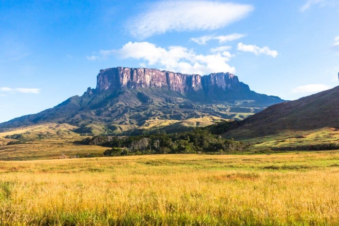
Terrain:
The Essequibo region is the largest and most sparsely populated region of Guyana, characterized by a diverse and challenging terrain. This terrain includes coastal plains, vast river systems, dense tropical rainforests, mountainous areas, and savannahs.

(Photo Credit: Wikipedia)
1.) Coastal Plains:
Low-lying plains, mangrove swamps, and mudflats characterize the coastal areas. These areas are prone to flooding, especially during the rainy season.
The coastal plains provide limited cover and concealment, making troop movements visible and vulnerable. Flooding and waterlogged conditions can hinder the mobility of heavy vehicles and equipment. Coastal areas are also crucial for logistics and supply lines due to their proximity to ports and infrastructure.
2.) River Systems:
The Essequibo River, one of the largest rivers in South America, along with its tributaries, dominates the region's landscape. These rivers are wide, deep, and have strong currents.
The Essequibo River serves as the hard border between the Essequibo region and the rest of Guyana.
The river can serve as a vital transport route for moving troops and supplies, especially in areas where road infrastructure is lacking. Control of the river would be strategic for maintaining logistical support as it feeds into various other tributaries and rivers.
The Cuyuni River is about 618 kilometers (384 miles) long, flowing through both Venezuela and Guyana. It is a tributary of the Essequibo River, joining it from the west. The river's basin is rich in natural resources, including gold and diamonds.
The Cuyuni River's location near the Venezuela-Guyana border makes it a potential flashpoint for conflict. Control of the river would be strategically important as it would enable Venezuela to move rapidly through the Essequibo region to the Essequibo River.
The Mazaruni River is approximately 560 kilometers (348 miles) long and is another major tributary of the Essequibo River. It flows through the central highlands of Guyana and is also rich in mineral resources.
The Mazaruni provides access to the interior regions, making it vital for deploying forces into remote areas.
The river's rapids and waterfalls present natural obstacles, requiring careful navigation and specialized equipment for riverine operations.
The Potaro River is a tributary of the Essequibo River, it contains the Kaieteur Falls, one of the highest single-drop waterfalls in the world. The river flows through the Potaro-Siparuni region and is approximately 225 kilometers (140 miles) long.
The Potaro River, particularly the area around Kaieteur Falls, is significant for tourism and national pride. Control over this area could have symbolic importance in addition to strategic value.
The presence of waterfalls and rapids makes navigation difficult, limiting the use of the river for transport but also provides natural defensive positions.
The river provides access to the interior regions, although its challenging terrain may restrict large-scale movements of troops and equipment.
The Ireng River forms part of the border between Guyana and Brazil. It flows through remote and rugged terrain, characterized by dense jungle and mountainous areas.
The river has numerous rapids and waterfalls, which can hinder navigation and transport.
The presence of rapids and waterfalls limits the number of viable crossing points, which can be easily monitored or defended.
The Takutu River also forms part of the border between Guyana and Brazil, further east of the Ireng River. It flows into the Rio Branco in Brazil.
Similar to the Ireng, the Takutu River serves as a border river, making it a strategic boundary.
Parts of the river are surrounded by floodplains, especially during the rainy season, which can create challenging conditions for movement.
The Takutu River has fewer rapids and waterfalls compared to the Ireng, providing more feasible crossing points for military operations.
The Takutu River Bridge, linking Lethem in Guyana to Bonfim in Brazil, is a critical piece of infrastructure for both civilian and military transport. Control of this bridge is vital for movement and supply.
The Barima River is an important waterway in the northwestern region of Guyana. It is one of the rivers that form part of the natural border with Venezuela.
It flows generally northwest towards the Atlantic Ocean, traversing through dense tropical rainforests and remote communities. The Barima River is approximately 220 kilometers (about 137 miles) long.
The Barima River is navigable for smaller vessels, which can be significant for the movement of supplies and personnel.
Control of the major rivers will be key to controlling the region. Military forces will need to focus on securing strategic points along these rivers to ensure dominance over both land and water routes.

(Photo Credit: GUYANA LANDS AND SURVEYS COMMISSION)
3.) Dense Tropical Rainforests:
Much of the interior of Essequibo is covered by dense, tropical rainforests. These areas are characterized by thick vegetation, high humidity, and a variety of wildlife.
The dense vegetation provides excellent cover and concealment, complicating reconnaissance and surveillance efforts. Movement through the rainforest is slow and challenging, necessitating the use of machetes and clearing tools.
The dense canopy of the jungle significantly reduces visibility for aerial reconnaissance and targeting. This makes it difficult to locate enemy positions and conduct effective airstrikes negating any aerial advantage Venezuela may have over Guyana.
The thick vegetation limits the availability of suitable landing zones for helicopters and other aircraft. Extraction and resupply missions will be hindered by the lack of clear areas for landing.
Small units will have to be utilized due to their mobile nature and ability to move through the dense vegetation more quietly and quickly than larger formations.
Small units operating in the jungle will require decentralized command structures, allowing them to operate independently and make quick decisions without relying on higher command for every move.
Due to the dense jungle, units will have to stay close to the major rivers to maintain supply.
4.) Mountains and Highlands:
The western part of the Essequibo region includes the Pakaraima Mountains, with rugged terrain and elevations reaching over 2,000 meters (6,600 feet).
The mountainous terrain provides natural defensive advantages and observation points.
The combination of mountains and the river rapids of the Ireng and Takutu rivers restricts the number of feasible routes for movement, focusing military operations on a few critical areas.
The Takutu River flows through the southwestern part of Guyana and forms part of the border with Brazil. This region includes the Kanuku Mountains to the east.
These mountains are lower in elevation compared to the Pakaraima range, but they still present significant obstacles with their rugged and forested terrain.
The Takutu River flows through a mix of floodplains and valleys, with mountainous areas providing a backdrop to the river’s course.
The Takutu River Bridge near Lethem is a crucial crossing point. Control over this bridge is vital for moving troops and supplies between Guyana and Brazil.
The Kanuku Mountains provide natural defensive positions that can be used to control movement along the river and protect strategic points like the Takutu River Bridge.
The floodplains along the river can become impassable during the rainy season, complicating ground operations.
(Photo Credit: inews Guyana)
5.) Savannahs:
In the southern part of the region, savannahs are characterized by open grasslands with scattered trees and shrubs. These areas have a distinct wet and dry season.
The open terrain of the savannahs allows for greater mobility of mechanized units but also exposes them to enemy observation and fire. Seasonal changes can affect the terrain's navigability, with dry conditions favoring rapid movement and wet conditions potentially causing vehicles to become bogged down.
Weather Conditions:
The Essequibo region of Guyana has a tropical rainforest climate, characterized by high temperatures, high humidity, and significant rainfall throughout the year.
1.) Seasons
May to Mid-August: This is the primary rainy season, with heavy and consistent rainfall.
November to January: The secondary rainy season is typically shorter and less intense than the primary one, but still marked by substantial rains.
Mid-August to October: Following the primary rainy season, this period experiences a noticeable reduction in rainfall.
February to April: This dry season follows the secondary rainy season and is generally the driest part of the year.

(Photo Credit: Region 2 Chairman, Parmanand Persaud | Guyana Chronicle)
2.) Temperature
The temperatures in the Essequibo region are relatively constant year-round, ranging from 24°C (75°F) to 30°C (86°F). Nighttime temperatures can occasionally drop slightly lower, but overall, the variation is minimal.
3.) Humidity
Humidity levels are high throughout the year, often exceeding 80%, which can exacerbate the heat and make conditions feel more oppressive.
4.) Rainfall
Annual rainfall in the Essequibo region typically exceeds 2,500 mm (98 inches), with some areas receiving even more. The frequent and intense rains can lead to flooding, especially in low-lying areas. Flooding can disrupt transportation, damage infrastructure, and isolate communities.
Flooded roads and swollen rivers can impede the movement of troops and supplies, making military operations more difficult.
5.) Tropical Diseases And Other Related Medical Challenges
High humidity and standing water provide ideal breeding conditions for mosquitoes, increasing the risk of diseases such as malaria, dengue fever, and chikungunya.
Flooding can contaminate drinking water sources, leading to outbreaks of diseases such as cholera and typhoid fever.
The combination of high temperatures and humidity can cause heat stress, dehydration, and heat stroke.
6.) Equipment Maintenance
The wet and humid environment can lead to rapid deterioration of equipment and supplies, requiring frequent maintenance and replacement.
Infrastructure:
1.) Roads
The Linden-Lethem Road is a crucial infrastructure artery in Guyana, connecting the riverside town of Linden on the eastern side of the Essquibo River to Lethem near the Brazilian border. It stands out as the only major road that can potentially connect Essequibo to Venezuela via the Troncal-10 in Venezuela to the BR-174/433/401 highway in Brazil.
The road is mostly dirt, with some paved sections. It is prone to flooding and becoming muddy, especially in the rainy season.
There is a section of dirt trails/roads that connect the town of Port Kaituma with the Five Star mining area, Mathews Ridge, and the town of Arakaka in the northern part of the Essequibo region.
The road connects to the Barima River which flows through the entirety of the Northern Essequibo region into Venezuela in the north connecting to the coastal plains.
The Essequibo Coast Road runs from the town of Charity on the Pomeroon River down the coast with the Atlantic to the town of Supenaam where the Supenaam Creek and the Essequibo River meet.
The Buckhall port road extends from the port of Buckhall on the Essequibo River to the interior of Essequibo stopping at the small village of Tapir, on the Cuyuni River.
The Kartabu-Puruni Road is an important route in the interior of Guyana, connecting the communities of Kartabu and Puruni in the Cuyuni-Mazaruni region to the city of Bartica on the Essequibo River.
The road continues across the Puruni River to the Toroparu gold mining project and its associated airstrip.
The Bartica-Potaro road connects Bartica with interior mining areas. It is largely unpaved and can be heavily affected by seasonal weather.
The Rupununi Road connects the Bartica-Potaro Road to the Linden-Lethem Road.

(Photo Credit: GISGeography)
2.) Bridges And Crossings
The Bartica Ferry Crossing operates across the Essequibo River, allowing vehicles and people to cross the river.
The Teperu Crossing is on the Kartabu-Puruni Road crossing the Mazaruni river.
The Puruni landing is a crossing on the Kartabu-Puruni Road over the Puruni river leading to the Toroparu gold mining project.
The Bartica-Potaro Road includes crossings over various rivers and creeks, such as the Potaro River.
The Linden-Lethem Road includes crossings over several rivers, including the Essequibo, Ireng, and Takutu Rivers. The Kurupukari Ferry crossing is one such example, crossing the Essequibo River. The Brazil-Guyana international bridge crosses the Takutu River into Brazil.
3.) Ports
The port of Bartica is a smaller port located at the confluence of the Essequibo, Mazaruni, and Cuyuni rivers. It serves as a hub for transportation within the Essequibo region, mainly handling river traffic and goods for local communities.
Port Kaituma is a small port located on the Kaituma River in the northern part of the Essequibo region. The port serves the various mining communities located here.
Buckhall Port is a minor port located on the Essequibo River and is connected to the Buckhall Port Road leading into the interior of the Essequibo region.
Several smaller ports are scattered along the Essequibo River and the various other rivers that run through the Essequbo region. These ports mainly handle timber, bauxite, and other resources extracted from the region.
4.) Airports/Airstrips
The Matthews Ridge Airport serves the community of Matthews Ridge and the surrounding North West District. It is a small airport with only one runway.
The Marbaruma Airport serves the town of Marbaruma and nearby communities in the Barima-Waini region. It is a small airport with one runway and it is close to the confluence of the Aruka and Bairima rivers.
Port Kaituma Airport is located in Port Kaituma and it is a small airport with one runway.
Baramita Airport is located in the remote interior of Guyana, specifically in the North West District of the Barima-Waini region. The airfield serves the indigenous community of Baramita and surrounding villages in the region.
Bemichi Airport is a small airport located in the northern part of Essequibo between Marbaruma Airport and the town of Charity.
Bartica Airport is located in the city of Bartica. It has one runway.
Paruima Airport sits close to the Venezuelan border, serving the communities around Upper Mazaruni. This airport has one runway.
The Kamarang Airport is a small airfield located near the village of Kamarang in the Cuyuni-Mazaruni region of Essequibo. It has one runway.
The Imbaimadai Airport is also located in the Cuyuni-Mazaruni region and it has one runway. It is one of the larger airports in the region with a runway length of approximately 1,219m (3,999ft).
Kaieteur International Airport is a midsized airport in Potaro-Siparuni, Essequibo. It has one runway. The Kaieteur Airport provides air access for tourists and visitors traveling to Kaieteur Falls, a major tourist attraction in Guyana.
The Mahdia Airport is a small airport near the town of Mahdia along the Rupununi Road. It has one runway of 1,067m (3,501ft).
The Lethem airport is the largest in the Essequibo region, on the border with Brazil. It has one runway which is approximately 1,825m (5,988ft) long.

Major Airports/Airstrips in Guyana
Force Composition and Disposition:
1.) Venezuelan Ground Forces:
42nd Airborne Brigade "Aragua”
The 42nd Airborne Brigade is designed for quick deployment to any part of Venezuela or neighboring regions. They can be inserted via parachute from fixed-wing aircraft or deployed by helicopters for air assaults. Their missions often involve securing key objectives such as airfields, bridges, and strategic locations ahead of larger, follow-on forces.
Composition: Brigade HQ, 421st Parachute Infantry Battalion, 422nd Parachute Infantry Battalion, 423rd Parachute Infantry Battalion, Sniper Company
11th Armored Brigade "Brigadier Pedro Ruiz Rondon"
Equipped with T-72B1V tanks and BMP-3 infantry fighting vehicles, this brigade would provide the necessary armored punch to break through defensive lines and support infantry advances.
Composition: Brigade HQ, 1st Battalion Combat Team (Mot.), 111th Armor Battalion, 112th Armor Infantry Battalion, 113th Armor Battalion, 114th Armor Battalion, 115th Field Artillery Battalion, 116th Air Defense Artillery Battalion, 1103rd Reconnaissance Squadron.
62nd Construction and Maintenance Regiment
The 62nd Construction and Maintenance Regiment is responsible for constructing and maintaining military infrastructure. This includes building roads, bridges, fortifications, and maintaining existing infrastructure to ensure that supply lines and troop movements are not hindered.
Composition: Regiment HQ, 621st Engineer Training Battalion, 622nd Engineer Battalion
99th Special Forces Brigade of the Army
This elite unit specializes in high-risk operations including direct action, reconnaissance, counter-terrorism, and unconventional warfare. They are trained for rapid deployment and operating behind enemy lines to disrupt command and control structures, gather intelligence, and execute targeted strikes.
8th Marine Special Operations Command “Brigade Generalissimo Francisco de Miranda”
This specialized unit is tasked with conducting a wide range of unconventional warfare operations, including reconnaissance, direct action, sabotage, counter-terrorism, and foreign internal defense. They operate in small, highly trained teams capable of operating independently behind enemy lines for extended periods.
Composition: HQ and Service Company, 81st Marine Special Operations (Commando) Battalion, 82nd Marine Force Reconnaissance Battalion, 83rd Marine Combat Engineers Battalion, 84th Marine Special Operations Support Battalion.
51st Jungle Infantry Brigade
The 51st Jungle Infantry Brigade is specialized in jungle warfare, utilizing their training to navigate, survive, and fight in dense jungle environments. They are adept at using the terrain to their advantage for ambushes and guerrilla tactics.
Composition: Brigade HQ, 511th Infantry Battalion (Jungle), 512th Infantry Battalion (Jungle), 513th Infantry Battalion (Jungle), 5102nd Reconnaissance Company, 5105th Mortar Battery (Jungle).
52nd Jungle Infantry Brigade
Similar to the 51st, the 52nd Jungle Infantry Brigade specializes in operations within jungle terrain. They are trained for long-range patrols, ambushes, and sustaining operations with minimal external support.
Composition: Brigade HQ, 521st Infantry Battalion (Jungle), 522nd Infantry Battalion (Jungle), 5202nd Cavalry Troop
1st Marine Infantry Brigade
The 1st Marine Infantry Brigade is tasked with amphibious operations, coastal defense, and rapid deployment for various missions including direct assault and securing beachheads. They are equipped to operate both on land and at sea.
Composition: Brigade HQ and Service Company, 11th Marine Battalion, 12th Marine Battalion (Assault Amphibian),13th Marine Field Artillery Battalion, 14th Marine Logistics Battalion.
5th Marine Riverine Brigade
The 5th Marine Riverine Brigade specializes in operations in riverine environments. They are equipped to conduct patrols, secure river banks, and launch assaults from riverine platforms.
Composition: Brigade HQ and Service Company, 1st Riverine Command, 2nd Riverine Command, 3rd Riverine Command, 1st Marine Fluvial Squadron, 5th Riverline Support Battalion, 5th Marine Air Group.
7th Marine Border Riverine Brigade
This brigade focuses on border security and operations in riverine areas near national boundaries. They conduct patrols to prevent illegal crossings, smuggling, and other border-related issues.
Composition: Brigade HQ and Service Company, 8th Upper Orinoco (Riverine) command, 9th Middle Orinoco (Riverine) command, 7th Marine Air Group, 7th Riverine Support Battalion
43rd Field Artillery Brigade "Grand Marshal of Ayacucho Antonio Jose de Sucre"
The 43rd Field Artillery Brigade provides artillery support to maneuver units, delivering indirect firepower to destroy or suppress enemy forces and fortifications.
Composition: Brigade HQ, 431st Field Artillery Battalion (Self-Propelled), 432nd Field Artillery Battalion (Self-Propelled), 433rd Field Artillery Battalion (Multiple Rocket Launcher), 434th Field Artillery Battalion (Multiple Rocket Launcher), 435th Field Artillery Battalion (Multiple Rocket Launcher).

(Photo Credit: r/SpecOpsArchive)
It is difficult to estimate the total number of personnel in Venezuelan military units due to variability in unit sizes and the lack of publicly available information. We can approximate a total number of combat personnel of 19,600-29,800 based on other similar units. This would align with the generally understood concept of having at minimum three-to-one odds when conducting an attack. (The total number of Guyanese military personnel across all branches is approximately 4,000-4,500).
2.) Venezuelan Grounded Forces Equipment:
Tanks: Venezuela currently has 180 tanks. This includes 92 T-72B1 main battle tanks and 80 AMX-30V2s modernized with new American engines and expanded fuel tanks. They also have 31 AMX-13 light tanks and 78 Scorpion-90 light tanks respectively.
Infantry Fighting Vehicles: Approximately 237 IFVs with 123 BMP-3s and 114 BTR-80As (unknown number of VN-1s)
Armored Personnel Carriers: Approximately 91 APCs with 25 AMX-VCIs, 12 AMX-PCs, 8 AMX-VCTBs, 36 Dragoon 300s, 10 TPz Fuchs.
Reconnaissance Vehicles/ Armored Cars: Approximately 431 Recon/Armored Cars with 42 Dragoons, 300 LFV2s, 79 V-100 and V-150s, 10 Panhard AML S 530s.
Towed Artillery: 105-millimeter (80) and 155-millimeter (24) field cannons from the United States and Italy.
Self-Propelled Artillery: Approximately 60 with 48 2S19 Msta-Ss (152mm) and 12 AMX-13/Mle F.3155mm (155mm)
Mortars: Approximately 61 with 48 2S12 Sanis (120mm) and 13 2S23 Nonas (120mm self-propelled mortars)
Multiple Rocket Launchers: Approximately 36 with 24 BM-21 Grads (122m) and 12 BM-30 Smerchs (300mm).
Air Defence: Approximately 338 with 12 BUK-M2s (self-propelled), 24 S-125 Pechora-2Ms (self-propelled), 2 S-300VMs (self-propelled), 300 ZU-23-2s (towed).
Small arms: The AK-103 (7.62×39mm) is the standard issue rifle however, older Cold War era rifles are also in service including the FN FNC (5.56×45mm), FAMAS F1 (5.56×45mm), QBZ-97 (5.56×45mm), and FN FAL (7.62×51mm).
Older Cold War era machine guns are still in service including the FN Minimi (5.56×45mm), FN MAG (7.62×51mm), M60 (7.62×51mm), and the M2HB Browning (12.7×99mm)
The SVD (7.62×54mmR) and the M700 (7.62×51mm) serve as Venezuela’s main designated marksman rifles (DMR).
Venezuelan infantry are also equipped with a variety of anti-tank and anti-air rocket launchers including the 9K338 Igla-S (SA-24 Grinch) (72mm), RPG-7 (40mm), AT4 (84MM), and the RBS 70 (106mm).

(Photo Credit: FilipeREP | r/TankPorn)
3.) Venezuelan Air Force:
Attack Helicopters: Approximately 9 Mi-35M2 Hinds.
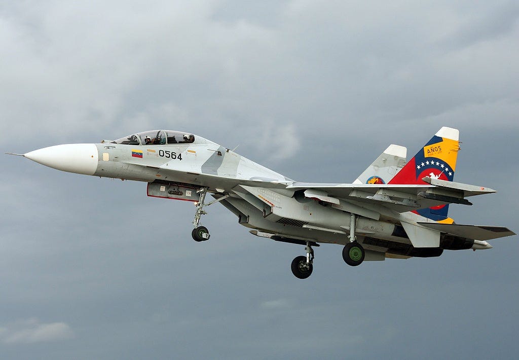
Multirole Fighter Jets: Approximately 40 with 18 F-16A/Bs and 22 Su-30MKVs.
Transport Fixed Wing: Approximately 56 of various types including 8 Shaanxi Y-8s, 3 Dornier Do 228s, 2 Short 360s, 5 King Airs, 4 Cessna 208s, 1 Cessna Citation II, 1 Metroliner IV, 3 C-130 Hercules, 3 IAI Aravas, 11 PZL M28 Skytrucks, 2 Cessna 207s, 2 Cessna 206s, 6 Cessna 182s, 1 Cessna 172, 1 Beechcraft Super King Air 200, 1 Beechcraft 90, 1 Beechcraft Super King Air 300
Transport Helicopters: Approximately 57 of various types including 26 Mil Mi-17V-5 Panares, 3 Mil Mi-26T-2 Pemóns, 3 Agusta Sea Kings, 3 Bell 206B Jet Rangers, 12 Bell 412 EPs, 10 Eurocopter AS532s.
Drones: Approximately 12 Mohajer-2 drones and various other smaller commercial drones.
(Photo Credit: André Austin Du-Pont Rocha)
4.) Venezuelan Navy:
Airplanes: Approximately 9 transport/patrol aircraft of various types including 2 C-212-200S43 Patrulleros, 3 C-212-400s, 1 B200, 1 B90, 1 Cessna 208 Caravan, 1 Turbo Commander.
Helicopters: Approximately 17 transport/attack helicopters of various types including 6 Mi-17V-5s, 2 Bell 206s, 9 Bell 212s.
Submarines/Minisubmarines: Approximately 2 with 1 Type 209 and 1 VAS 525
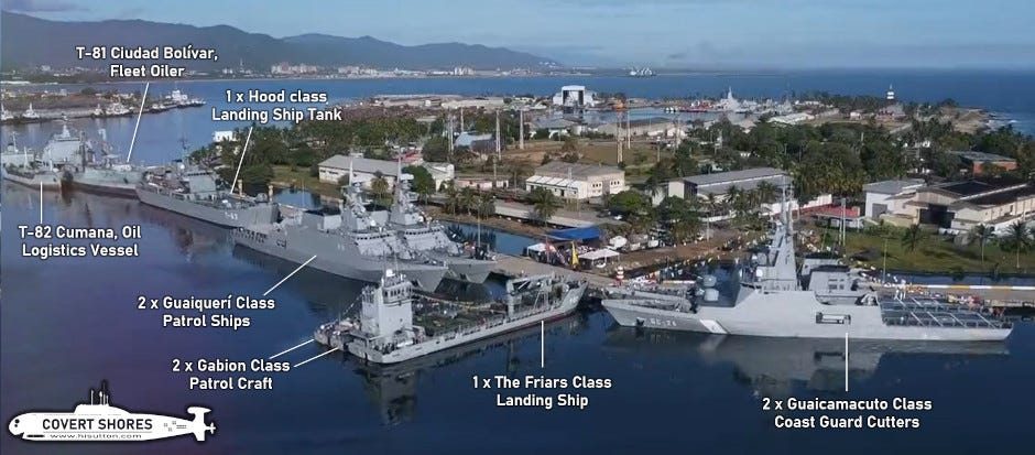
Frigates: Approximately 1 Mariscal Sucre class frigate.
Offshore Patrol Vessels: Approximately 3 Guaiquerí Class patrol ships
Gunboats: Approximately 3 Constitución class gunboats
Patrol Boats (Missile Boats): Approximately 18 with 4 Peykaap-III class missile boats, 2 Págalo class patrol boats, and 12 Gavión class patrol boats.
Amphibious Landing Crafts: Approximately 8 with 4 Capana class Landing Ship Tanks and 4 Friars Class landing ships.
Supply/Service Ships: Approximately 1 Ciudad Bolívar class supply ship
Speedboats/Amphibious Armoured Personnel Carries: The Venezuelan Marine Corps and Navy operate various purpose-built and improvised speedboats from a variety of sources including the United States Guardian patrol speedboats, Caroní, Manapiare, Caimán, 22 Apure/Apure II assault launches, and US Coibas. They also have a variety of AAPCs including American AAV-7s, Chinese VN1s, Chinese VN16s, Brazilian Engesa EE-11 Urutus, and Chinese VN18 Amphibious Light Tanks.
(Photo Credit: H I Sutton)
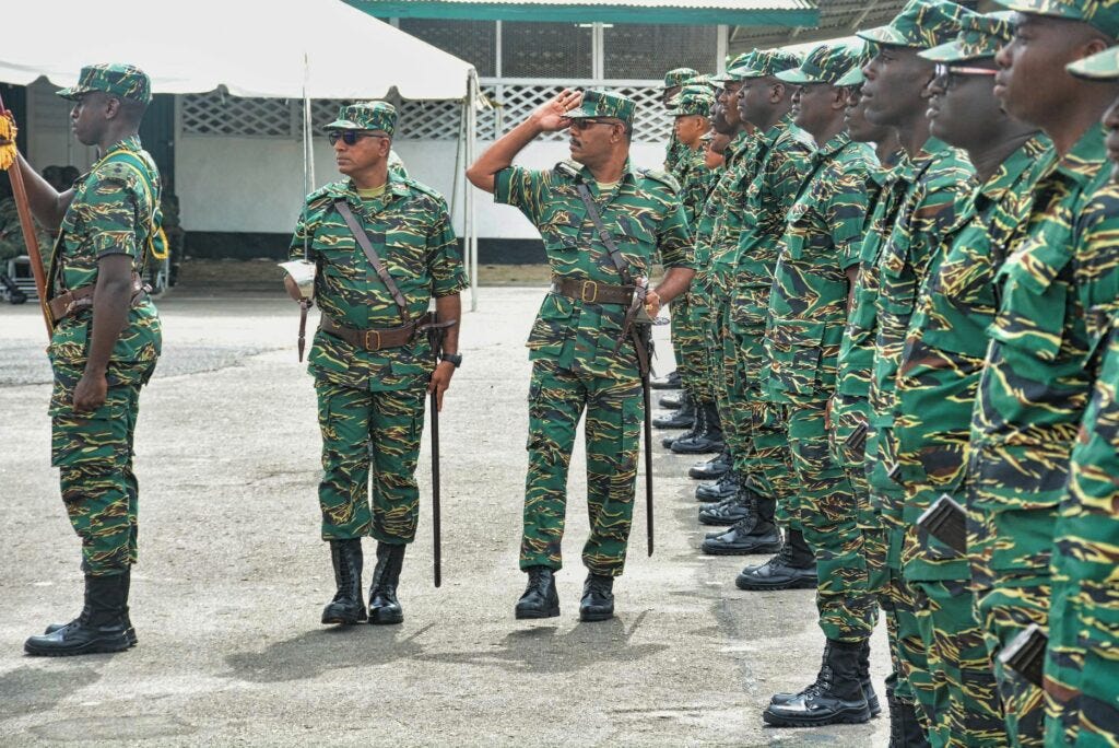
5.) Guyanese Ground Forces:
1st Infantry Battalion Group
3rd Infantry Battalion
2nd Infantry Battalion Group Reserve (Reserve volunteer unit)
31 Special Forces Squadron proficient in airborne, riverine, and jungle operations.
21st Artillery Company provides artillery support to maneuver units, delivering indirect firepower to destroy or suppress enemy forces and fortifications.
Engineer Battalion supports combat operations by providing engineering expertise and capabilities such as explosive ordnance disposal, constructing fortifications and defensive structures, and bridging operations.
Approximately 3,500-4,000 combat personnel.
(Photo Credit: Guyana Defence Forces)
6.) Guyanese Ground Forces Equipment:
Armored Fighting Vehicles: Approximately 35 with 6 EE-9 Cascavel armored cars, 24 EE-11 Urutu amphibious armored personnel carriers, and 5 Shorland S52 armored cars.
Artillery: Approximately 12 with 6 M-46 (130mm), and 6 Type 63 (107mm) multiple rocket launch systems. A possible unknown amount of Soviet D-30 122-millimeter howitzers and 76-millimeter guns.
Mortars: Approximately 48 with 12 L16A1s (81mm), 18 M-43s (82mm), 18 M-43s (120mm)
Small Arms: Cold War era rifles AKMS (7.62×39mm), Type 56s (7.62×39mm), SKSs (7.62×39mm), Type 63s (7.62×39mm), M16s (5.56×45mm), FAMASs (5.56×45mm), G36s (5.56×45mm), FN FALs (7.62×51mm), and G3s (7.62×51mm)
Cold War Era Machine Guns such as FN MAGs (7.62×51mm), AA-52s (7.62×51mm), Bren Guns (7.62×51mm), FN Minimis (5.56×45mm), and 14.5 mm heavy machine guns (approximately 6)
Anti-tank and anti-air rocket launchers include 9K32 Strela-2s (72mm), RPG-7s (40mm), and 82mm recoilless rifles

(Photo Credit: Tack68 (CCA-SA4) | Wikimedia Commons | SÉBASTIEN ROBLIN)
7.) Guyanese Air Force:
Transport Fixed Wing: Approximately 8 with 1 BN-2 Islander, 1 Cessna 206, 2 HAL 228s, 2 Short Skyvans, 1 Super King Air, and 1 Harbin Y-12.
Transport/ Utility Helicopters: Approximately 4 with 2 Bell 206s and 2 Bell 412s.

(Photo Credit: Guyana Defence Forces)
8.) Guyanese Navy:
Patrol Boats: Approximately 7 with 5 28-foot Relentless Class patrol boats, and 2 38-foot Defiant Class patrol boats. 1 “unserviceable” River-class minesweeper GDFS Essequibo that could hypothetically be recalled back to service.

(Photo Credit: Metal Shark Boats | Linkedin)
Command And Control:
1.) Venezuelan Comand And Control:
Venezuela is likely to adopt a centralized command structure similar to Argentina's during the 1982 Falklands War. This means the strategic decisions and overall control will emanate from high-level military and political leaders based in Caracas.
High Command (Comando Estratégico Operacional, CEOFANB): Based in Caracas, the CEOFANB would oversee the entire operation, coordinating between different branches of the military. It reports to both the President and to the Minister of Defense
The Integral Strategic Defense Regions or ISDRs (REDI, Regiones Estrategicas de Defensa Integral) are equvilaent to regional commands.
REDI Marítima e Insular (Maritime and Insular Integral Strategic Defense Region)
Commander: Vice Admiral Alexander Velásquez Bastidas, Venezuelan Navy
Responsibilities: Overseeing naval operations, securing sea lanes, and supporting amphibious operations. This REDI would coordinate the deployment of marine units and naval assets for initial landings, riverine operations, and coastal operations in Essequibo.
REDI Guayana (Guyana Integral Strategic Defense Region)
Commander: Lieutenant General Carlos Leal Telleria, Venezuelan Army
Responsibilities: Leading ground operations within the Essequibo region, including armored and infantry advances. This REDI would focus on establishing control over strategic areas, maintaining supply lines, and supporting logistical operations.
REDI Oriental (Eastern Integral Strategic Defense Region)
Commander: Lieutenant General Winder González Urdaneta, Venezuelan National Guard
Responsibilities: Managing eastern border security and supporting operations in adjacent areas. This REDI would provide additional ground forces and coordinate with REDI Guayana to secure eastern approaches and border regions.
Command And Control Challenges and Limitations:
Communication Infrastructure: The dense jungle and rugged terrain of the Essequibo region could impede communication between units and with the central command.
Coordination of Air and Naval Support: Just as Argentine air attacks were directed from the mainland, Venezuelan air and naval forces might face difficulties in synchronizing their operations with ground troops due to the geographical separation.
Logistical Strain: Maintaining supply lines and supporting an extended campaign in the challenging environment of Essequibo would require immense logistical planning and execution.
Potential Command and Control Advantages:
UAVs and Reconnaissance Assets: Venezuela has a variety of unmanned aerial vehicles and other reconnaissance tools at its disposal that can be used to provide real-time intelligence and improve situational awareness.

(Photo Credit: FEDERICO PARRA | Getty Images | SÉBASTIEN ROBLIN)
2.) Guyana Command And Control:
Centralized Strategic Command
Location: Likely based in the capital, Georgetown.
Function: Centralized command for strategic planning, resource allocation, and coordination with international allies and support networks.
Role: The Chief of Staff, alongside key advisors and senior officers, would operate from this central hub to maintain overall control and strategic oversight of the defense operations.
Chief of Staff
Current Chief of Staff: Brigadier Omar Khan
Responsibilities: As the professional head of the GDF, Brigadier Khan is responsible for the administration and operational control of the military. In an invasion scenario, he would oversee the strategic defense operations and ensure coordination between different units and branches of the military.
")
(Photo Credit: Office of the President Of Guyana)
Sector Command Posts
Function: Serve as localized C2 hubs within the respective sectors of the Essequibo region.
Role: Each sector command post would manage local defense efforts, including troop deployments, intelligence gathering, and coordination with civilian authorities and local militias.
1st Infantry Battalion Group
Composition: The primary ground force responsible for the defense of the Essequibo region. This unit would undertake tasks previously managed by multiple battalions, including patrolling, reconnaissance, and direct combat operations.
Advantages: The GDF can set up command posts in strategically advantageous locations, using their knowledge of the terrain to ensure secure and concealed positions. This minimizes the risk of detection and attack by enemy forces.
Rapid Reaction: Familiarity with the local geography allows the GDF to quickly reposition forces in response to enemy movements, maintaining the flexibility and adaptability of their command and control structures.
Community Networks: The GDF can benefit from local intelligence networks that can provide timely and accurate information about enemy activities. The ability to gather and analyze real-time intelligence from local sources enhances situational awareness and allows commanders to make more effective decisions.
Challenges: The amalgamated battalion faces significant operational challenges due to limited resources, both human and material, which could impact its ability to effectively respond to an invasion.
Cyber Vulnerabilities: Limited cyber defense capabilities make the GDF's command and control systems susceptible to electronic warfare and cyberattacks from a technologically superior Venezuela
Terrain: While the GDF has an advantage in familiarity with the terrain, the dense jungles, rivers, and mountainous areas of Essequibo can also impede movement and communication. This can isolate units and make coordinated efforts more difficult.
Sector Command Posts
Amawai Sector
Roraima Sector
Ireng Sector
Takutu Sector
Kutari Sector
Potential Advantages:
Advanced Communication Systems: Allies like the US and the UK could provide advanced communication equipment and systems, including secure satellite communication
Aerial and Satellite Reconnaissance: The US and UK possess advanced ISR capabilities, including satellite imagery, drones, and reconnaissance aircraft. These assets could provide real-time intelligence on enemy movements, positions, and activities, giving the GDF a critical advantage in situational awareness.
Human Intelligence (HUMINT): Allied nations could assist in gathering HUMINT, leveraging their global networks and expertise to provide actionable intelligence.
Advisors and Mentors: Embedding experienced military advisors within GDF units would provide real-time guidance and mentorship, improving command and control processes and decision-making.
Cyber Capabilities: Allies could offer cyber defense and offensive capabilities, protecting GDF command and control networks from cyberattacks and potentially disrupting enemy communications.
International Presence: The visible presence of international allies can boost the morale of GDF personnel and the civilian population, demonstrating that Guyana is not isolated and has strong international backing.
Psychological Operations: Allies can assist in conducting psychological operations (PSYOP) to counter enemy propaganda and bolster the resolve of GDF forces and the local population.
Sanctions and Diplomatic Pressure: Allies can exert diplomatic pressure on Venezuela through sanctions and international forums, potentially limiting Venezuela's ability to sustain prolonged military operations.
Mission And Execution:
1.) Venezuelan Mission: Secure control over the Essequibo region by capturing key airfields and establishing freedom of maneuver along strategic rivers and roads. Ensure a lasting Venezuelan presence can be maintained in the area. Politically assert Venezuelan sovereignty over Essequibo to deter opposition from local and international actors.
2.) Execution:
Seize Key Objectives: Conduct coordinated operations to capture vital airfields and swiftly secure strategic points along rivers and roads in the Essequibo region.
Defensive Posture: Quickly seize control of the entirety of the west bank of the Essequibo River and the border crossing with Brazil setting up a hasty defensive posture to repel any counterattacks by Guyanese forces and consolidate control over the Essequibo region.
Establish Operational Presence: Set up bases and checkpoints to maintain a continuous Venezuelan presence and control over the region.
Ensure Mobility: Control key transportation routes to facilitate rapid movement of Venezuelan forces and supplies.
Coordinate Air and Naval Support: Utilize air and naval assets to support ground operations, including reconnaissance and interdiction of enemy movements.
Suppress Opposition: Neutralize any resistance from local defense forces or militias through targeted operations aimed at disrupting their command and control.
Demonstrate Sovereignty: Showcase Venezuelan control over Essequibo through effective governance and administration of the region.
3.) End State: Venezuelan forces have established control over key areas in Essequibo, ensuring a permanent presence and demonstrating Venezuelan sovereignty. The region is effectively governed and integrated into Venezuelan territory, dissuading any opposition from local or international actors.
4.) Guyanese Mission: Defend the Essequibo region by securing key defensive positions and denying Venezuelan forces access to critical infrastructure and territory. Conduct delaying actions to prolong the conflict and buy time for international support to bolster Guyana's defense of the Essequibo region.
5.) Execution:
Establish Defensive Positions: Deploy forces to key defensive positions along likely avenues of Venezuelan advance, focusing on chokepoints, river crossings, and critical infrastructure.
Disrupt Enemy Advancement: Employ guerrilla tactics, ambushes, and hit-and-run attacks to disrupt Venezuelan movements, slow their progress, and degrade their combat effectiveness.
Conduct Spoiling Attacks: Launch preemptive strikes and raids to harass Venezuelan forces, sabotage supply lines, and degrade their morale and cohesion.
Utilize Terrain Advantage: Exploit natural terrain features such as dense jungles, rugged mountains, and waterways to impede enemy movements and force them to expend time and resources navigating difficult terrain.
Employ Asymmetric Warfare: Leverage unconventional warfare tactics, including irregular forces and militia units, to create uncertainty and complicate Venezuelan command and control efforts.
Coordinate International Support: Engage diplomatic channels to garner international support for Guyana's defense, including military assistance, sanctions against Venezuela, and diplomatic pressure to de-escalate the conflict.
Preserve Critical Infrastructure: Protect vital infrastructure such as airfields, ports, and communication networks to maintain logistical support and ensure the continuity of operations.
Maintain Morale and Resolve: Foster unity and resilience among Guyanese forces and the civilian population, emphasizing the importance of defending national sovereignty and territorial integrity.
Prepare for Escalation: Anticipate potential escalation scenarios and adjust defense plans accordingly, including mobilization of reserve forces and activation of contingency measures to respond to changing dynamics.
Exploit Diplomatic Leverage: Leverage diplomatic initiatives and negotiations to seek a peaceful resolution to the conflict while simultaneously strengthening military deterrence against Venezuelan aggression.
6.) End State: Guyana successfully delays Venezuelan advancement, preserving territorial integrity and sovereignty over the Essequibo region while securing international support for a diplomatic resolution to the conflict.
Ground Campaign: In a potential invasion of the Essequibo region, Venezuelan ground forces would likely pursue a multi-pronged offensive operation aimed at securing key objectives and rapidly establishing control over the territory. The main line of advance would be along the Cuyuni River, with Anacoco Island serving as a strategic jumping-off point for military operations.

(Photo Credit: FT | Planet Labs PBC)
Special Forces: Special forces units would be deployed ahead of the main invasion force conducting reconnaissance and sabotage/disruption operations to undermine enemy morale, disrupt supply lines, and sabotage critical infrastructure.
Advance Along the Cuyuni River: Venezuelan forces would push eastwards along the Cuyuni River, aiming to establish control over key towns and infrastructure along its banks. Anacoco Island would serve as a logistical hub and staging area for further operations. Troops would likely be deployed to secure river crossings and establish a presence in strategic locations along the river.
Simultaneous Advance in the North: In parallel, Venezuelan forces would advance in the north along the Barima River, aiming to secure key roads and communities in the northwestern region of Essequibo. Towns like Mabaruma and Port Kaituma would be targeted to establish control over important transportation routes and population centers. The road connecting Port Kaituma to Mathews Ridge would be of particular importance for securing access to inland areas.
Push Towards the Mazaruni River: Venezuelan forces would also seek to push towards the Mazaruni River, aiming to establish control over this important waterway and the surrounding territory. Securing the Mazaruni River would further enhance Venezuela's ability to project power and control movement in the region.
Secure Bartica and Surrounding Areas: Bartica, located at the confluence of the Essequibo, Mazaruni, and Cuyuni rivers, would be a key objective for Venezuelan forces. Securing Bartica and its surrounding roads would enable Venezuela to establish control over crucial transportation routes and the border crossings with Brazil in the southern part of Essequibo.
Utilize Air Assault Forces: To rapidly secure airfields and other strategic locations, Venezuelan forces would likely employ air assault tactics using helicopters. These forces would be deployed to quickly seize control of key infrastructure and deny access to enemy forces. Airfields would be particularly important targets to establish logistical support and reinforce ground operations.

(Photo Credit: LEO RAMIREZ | Getty Images | SÉBASTIEN ROBLIN)
To defend against a potential invasion of the Essequibo region, Guyanese forces would focus on securing key roads, rivers, and other critical infrastructure to impede the advance of Venezuelan forces, while simultaneously relying upon asymmetrical warfare tactics to slow the Venezuelan offensive.
The Linden-Lethem Road is a major roadway that serves as the primary land route connecting the coastal region of Guyana to the border with Brazil. Guyanese forces would likely establish defensive positions along this road to prevent Venezuelan forces from advancing southward and to protect vital transportation routes.
Likewise, the Bartica-Potaro Road and the Port Kaituma to Five Star Road are both important roads that provide access to the interior of Essequibo. Guyanese forces may prioritize securing these roads to maintain access to interior regions and to prevent Venezuelan forces from advancing deeper into Guyanese territory.
Guyanese forces would likely establish defensive positions along the Cuyuni River to prevent enemy crossings and to maintain control over key river crossings and bridges.
Similar to the Cuyuni River, the Mazaruni River presents another potential route for enemy forces to penetrate deeper into Guyanese territory. Guyanese forces would aim to control strategic points along the Mazaruni River to deny access to Venezuelan forces and protect critical infrastructure.
Guyanese forces would continuously harass Venezuelan troops, denying them rest and forcing them to remain on high alert. This would involve nightly raids on camps and supply depots, ambushes, mines/IEDs/booby traps, and avoiding decisive engagements opting for smaller-scale pitch battles instead.
Maritime Arena: Due to Venezuela’s limited amphibious assault capabilities, Venezuelan amphibious operations would likely be limited to small-scale riverine operations and landings in the northern less populated coastal areas of Essequibo. This means an amphibious assault on coastal cities like Bartica is out of the question. The Venezuelan Navy would attempt to screen the opening of the Essequibo River to prevent Guyanese ships from entering via the Atlantic.
Mariscal Sucre Class Frigate: Positioned to assert control over major maritime routes along the Essequibo coast and support amphibious operations.
Guaiquerí Class Patrol Ships: Conduct patrols along the coast, monitor Guyanese naval movements, and engage Guyanese patrol boats if necessary.
Ciudad Bolívar Class Supply Ship: Ensure continuous supply of ammunition, fuel, and provisions to frontline units. This ship would operate from a secure, offshore location to minimize the risk of engagement.
Constitución Class Gunboats: Provide additional firepower and provide security for supply ships operating in the various rivers in the Essequibo region.

(Photo Credit: Nilo García (CCA-SA3) | Wikimedia Commons | SÉBASTIEN ROBLIN)
The Guyanese maritime strategy would be completely defensive, as the Guyanese navy can not under any circumstances afford a direct naval engagement with Venezuelan forces. Instead, the Guyanese would use their navy to disrupt the Venezuelan supply lines and support the ground forces.
Relentless Class Patrol Boats and Defiant Class Patrol Boats: Focus on coastal regions around Georgetown, Essequibo River, and key points like Bartica, Mabaruma, and Port Kaituma.
Lay mines at strategic chokepoints, especially at the mouths of rivers like the Cuyuni, Barima, and Mazaruni to hinder Venezuelan naval movements.
Use small, agile patrol boats to launch surprise attacks on Venezuelan supply lines and isolated naval units, particularly in narrow waterways and coastal areas.
Aerial Arena: Due to the nature of the terrain and dispersed disposition of Guyanese forces the Venezuelan Air Force would be used more in a support role than direct kinetic operations. The main focus of the Air Force would be troop transportation, medical evacuations, and resupply operations. Since the Guyanese do not have any combat aircraft the main concern for the Venezuelans would be ground-based MANPADS although the Guyanese only possess small numbers of 9K32 Strela-2 Systems.
Mi-35M2 Hinds: Provide close air support for ground troops, targeting Guyanese defensive positions, armored units, and supply lines.
Mi-17 and Mi-26 Transport Helicopters: Deploy special forces and airborne units rapidly to strategic locations, such as airfields and key road intersections, to secure them ahead of the main ground forces.
Bell and Eurocopter AS532 Helicopters: Conduct reconnaissance and support missions.
Mohajer-2 Drones: Provide real-time intelligence, surveillance, and reconnaissance (ISR) capabilities to monitor Guyanese movements, supply lines, and potential counterattacks.
F-16s and Su-30s: There is a roughly even chance that the Venezuelan Air Force would conduct limited ground attack missions targeting rearward areas on the eastern side of the Essequibo River (military installations near Georgetown). If the war becomes protracted Venezuelan forces may ramp up airstrikes to put pressure on the Guyanese forces.

(Photo Credit: Maxim Zmeyev | REUTERS)
The Guyanese do not possess any combat aircraft that could challenge Venezuelan air superiority or conduct airstrikes in support of defending soldiers. Instead, Guyanese aerial assets would almost certainly be used in a supportive manner, providing logistical support for defending forces. Guyanese defensive ariel operations would be focused on using ground-based anti-air systems.
Transport and Utility Helicopters: Use for rapid redeployment of forces, medical evacuations, and supply runs.
Transport Fixed Wing Aircraft: Support logistics and strategic movement of troops and supplies.
RPG-7 and Strela-2 Units: Position near key airfields, supply routes, and potential Venezuelan landing zones.
14.5 mm heavy machine guns: Position in concealed areas near airfields to target Venezuelan helicopters and smaller transport fixed-wing aircraft.
Logistics: Logistics play a crucial role in any military campaign, and the complex terrain of the Essequibo region presents significant challenges for both Venezuelan and Guyanese forces. Much like the British and Argentine forces in the Falklands War, both sides in this conflict will face severe logistical constraints, relying heavily on rivers, airfields, and limited road networks for the movement of troops and supplies.
1.) Venezuelan Logistics
Cuyuni River: This river will serve as a primary supply route for Venezuelan forces advancing from Anacoco Island. Using the river for the transport of troops, ammunition, and supplies will be crucial, but also makes the supply lines vulnerable to ambushes and disruptions by Guyanese forces.
Mazaruni River: Venezuelan forces pushing to secure the Mazaruni River will face similar challenges. Ensuring a steady flow of supplies through this route will be essential to maintain their operational momentum.
Anacoco Island Airfield: Venezuelan forces will rely on this airfield to receive supplies and reinforcements. Helicopters will be critical for moving supplies from the airfield to forward units, especially in areas lacking road access.
Forward Airfields and Helicopter Operations: As Venezuelan forces advance, they will need to secure and utilize other airstrips within the Essequibo region to sustain their operations. Transport helicopters like the Mi-17s and Mi-26s will be essential for resupplying isolated units and moving heavy equipment.
Limited Road Infrastructure: The lack of developed roads in the Essequibo region will force Venezuelan forces to depend on narrow jungle paths and makeshift routes for ground transport. This will slow down the movement of heavy equipment and bulk supplies, increasing their reliance on aerial and riverine logistics.
Ambushes and Guerrilla Tactics: Guyanese forces can exploit the vulnerabilities of Venezuelan supply lines by using guerrilla tactics to ambush supply convoys on rivers and at choke points along the limited road network.
Weather Conditions: Bad weather can disrupt aerial resupply missions and reduce the roads to unusable muddy swamps. This can lead to critical shortages of food, ammunition, and medical supplies for front-line units.

(Photo Credit: Meredith Kohut | New York Times)
2.) Guyanese Logistics
Essequibo and Mazaruni Rivers: Guyanese forces will use these major rivers to transport troops and supplies to defensive positions and forward operating bases. However, the rivers can become points of contention and targets for Venezuelan attacks.
Riverine Units: Utilizing small boats and patrol vessels, the Guyanese Navy can support logistical operations while also engaging in hit-and-run tactics to disrupt Venezuelan supply lines.
Strategic Airfields: Key airstrips like those at Bartica and Mabaruma will be critical for receiving supplies and reinforcements. Guyanese forces will need to defend these airfields against Venezuelan attacks.
Helicopter Operations: Limited helicopter assets (Bell 206s and Bell 412s) will be stretched thin, requiring careful prioritization of missions to ensure critical supplies reach front-line units.
Sparse Infrastructure: The sparse road network beyond key towns like Bartica and Lethem will hamper the movement of supplies. Guyanese forces will have to rely on improvised routes and manpacking supplies to remote positions.
Long Supply Lines: As forces move further from major supply hubs, maintaining a steady flow of resources will become increasingly difficult. Guyanese forces will need to establish forward supply depots and caches to sustain operations.
Interdiction Operations: By targeting Venezuelan supply lines with guerrilla tactics and small unit ambushes, Guyanese forces can prolong the conflict and stretch Venezuelan logistics to the breaking point.
Both sides will rely heavily on helicopters for resupply due to the challenging terrain and limited road infrastructure. Securing and defending key airfields will be a priority for both Venezuelan and Guyanese forces. Loss of these airfields could critically disrupt logistics. Rivers will also serve as vital supply routes for both sides. Control of these waterways will be fiercely contested, with both sides attempting to use them for their logistics while disrupting the enemy’s use. The dense jungle terrain and variable weather conditions will complicate logistics for both sides. Both will need to establish secure supply caches and forward operating bases to mitigate the impact of supply disruptions.
Scenario 1: Operación Rayo del Orinoco
Venezuela Rapidly Secures Essequibo
Probability: Unlikely
In this scenario, Venezuelan forces rapidly advance into the Essequibo region, effectively steamrolling any initial opposition. The mission begins with a coordinated effort to capture vital airfields and secure strategic points along the Cuyuni, Mazaruni, and Barima rivers. As part of their defensive posture, Venezuelan troops quickly secure the west bank of the Essequibo River and establish control over the border crossing with Brazil. They set up hasty defensive positions on the eastern side of the Essequibo River before Guyana can muster an effective defense. Regional players such as Brazil and Colombia will be vital for negotiations, diplomatically ending the conflict. To maintain control, Venezuelan forces establish operational bases and checkpoints throughout the region, ensuring a continuous presence. To assert sovereignty, Venezuelan forces establish visible governance and administrative buildings, providing public services to win local support. By effectively demonstrating Venezuelan control over Essequibo, they deter any opposition from local or international actors. In the end state, Venezuelan forces successfully annexed Essequibo, securing a major political victory for Maduro and access to the vast offshore oil deposits making Venezuela an even more significant player in the global oil market.
Scenario 1b: Operatie Nieuw Nickerie
Taking advantage of the situation, Suriname launches an opportunistic invasion of Guyana to seize disputed territory, further putting pressure on Guyana.
Probability: Remote
Suriname may view Venezuela's invasion as an opportunity to assert its territorial claims against Guyana. In this scenario, Suriname launches an opportunistic invasion of the New River Triangle, seeking to capitalize on Guyana's vulnerability and further pressure its neighbor. However, the probability of this scenario occurring is remote, as it would likely provoke strong international condemnation and resistance from Guyana and other neighboring countries.
Scenario 2: Operación Escudo Patriótico
Venezuela’s offensive becomes bogged down and similar to Ukraine becomes a protracted and costly conflict with Venezuela ultimately annexing parts of the Essequibo region.
Probability: Likely
In this scenario, Venezuela launches an offensive to secure the Essequibo region, but the operation quickly becomes bogged down, resulting in a protracted and costly conflict. Initially, Venezuelan forces make some advances, capturing key airfields and securing strategic points along the Cuyuni, Mazaruni, and Barima rivers. However, stiff resistance from Guyanese forces and logistical challenges slows their progress. As Venezuelan troops move deeper into Essequibo, they encounter well-organized Guyanese defensive positions and guerilla-style tactics aimed at disrupting their supply lines and communication networks. Guyanese forces utilize the difficult terrain and limited infrastructure to their advantage, conducting ambushes and hit-and-run attacks to inflict casualties and slow the Venezuelan advance. Venezuelan efforts to secure control over key transportation routes and airfields face significant hurdles, as Guyanese forces destroy bridges, mine roads, and use small boats to harass Venezuelan patrols along the rivers. The Venezuelan military struggles to maintain supply lines, relying heavily on air and river transport, which are frequently targeted by Guyanese forces. Despite these challenges, Venezuela manages to establish a foothold in parts of the Essequibo region. They set up defensive positions and fortify captured towns, but progress is slow and costly. The conflict drags on, drawing significant resources and attention from the Venezuelan government and military. As the conflict continues, international attention increases, with calls for a diplomatic resolution. The prolonged fighting takes a toll on both sides, with mounting casualties and economic costs. Despite the difficulties, Venezuela eventually annexes parts of the Essequibo region, but the victory is Pyrrhic. The region remains contested and unstable, and Venezuela faces ongoing insurgency and international condemnation.
In the end state, Venezuela secures partial control over the Essequibo region, but the conflict remains unresolved and costly. The annexation is incomplete, with parts of the region still under Guyanese control or heavily contested. The situation remains a significant political and military challenge for the Maduro regime, similar to the protracted conflict seen in Ukraine.
Scenario 3: Operation Guyana Guardian
Guyanese forces mount a stubborn and effective defense against a Venezuelan invasion and after halting the Venezuelans before they could secure key objectives the Guyanese force Venezuela to withdraw after inflicting significant casualties.
Probability: Remote
In this scenario, Guyanese forces demonstrate resilience and effectiveness in repelling the Venezuelan invasion. Despite facing a larger and more heavily armed adversary, the Guyanese military successfully halts the Venezuelan advance and prevents them from securing key objectives in the Essequibo region. Through determined defensive actions and coordinated efforts, the Guyanese forces inflict significant casualties on the Venezuelan invaders, forcing them to withdraw from the region.
The political ramifications for Maduro and Venezuela in this scenario could be substantial. A failed invasion of Essequibo would be a significant blow to Maduro's leadership and his administration's credibility. It would highlight the limitations and vulnerabilities of the Venezuelan military despite its numerical superiority. The inability to achieve their objectives in the face of determined resistance from a smaller neighbor like Guyana would undermine Maduro's claims to regional dominance and could lead to internal discontent and challenges to his authority. Internationally, Maduro's failed military adventure could result in diplomatic isolation and increased pressure from neighboring countries and the international community. It may prompt regional powers such as Brazil, the United States, and others to bolster their support for Guyana and take a more active stance against Venezuelan aggression. Additionally, it could further strain Venezuela's already fragile economy and exacerbate domestic unrest, potentially leading to increased instability within the country or ultimately a coup against the Maduro regime.
Scenario 4: Operation Hemispheric Shield
Guyanese forces successfully slow down the Venezuelan invasion allowing valuable time to engage diplomatically with regional allies such as Brazil and the United States. Guyana successfully rallies international support and a coalition is formed to repel the Venezuelan invasion. The coalition will be defensive, with the sole objective of repealing the Venezuelan invasion, similar to the 1991 Gulf War.
Probability: Very Likely
In this scenario, Guyanese forces manage to slow down the initial Venezuelan invasion, buying valuable time for diplomatic efforts to rally regional allies. The United States and the United Kingdom provide intelligence gathered from satellite imagery, reconnaissance flights, and signals intelligence, bolstering Guyana’s ability to defend. International organizations with support from the Guyanese diaspora provide vital humanitarian assistance. President Lula of Brazil initially stalls intervention, preferring diplomatic solutions. However, as military and diplomatic pressure mount, he is forced to intervene, providing a significant portion of the ground forces for the coalition. The United States takes the lead in the coalition, imposing a naval blockade on Venezuela with its allies and launching airstrikes into Venezuela using carrier-based planes and naval missile launchers. They also contribute a small contingent of ground forces (82nd Airborne and 75th Rangers 1st or 3rd Bn) and special operations soldiers, similar to the involvement in the invasion of Grenada. The United Kingdom joins the coalition, providing naval assets and a small contingent of Royal Marines. Argentina rallies other Latin American countries to the cause, providing a small contingent for the naval blockade, with Paraguay and possibly Peru also contributing token forces. Chile and France may also offer assistance, albeit less likely. Other Caribbean countries may also join the coalition, along with Canada. Brazil, being the largest regional power, contributes significantly to the coalition by providing a substantial portion of ground forces. They also offer logistical support, including transportation and supply lines for the coalition troops. Argentina and other Latin American countries provide additional material support, such as naval vessels, aircraft, and ground troops, albeit on a smaller scale compared to Brazil and the United States. In terms of the military campaign, coalition forces adopt a multi-pronged approach to push Venezuela out of Essequibo. The timeline for the operation unfolds as follows:
Initial Deployment (Week 1): Coalition forces rapidly deploy to key staging areas, including Guyana and neighboring countries. Brazil mobilizes its ground forces and begins moving towards the Venezuelan border, while U.S. naval assets establish a blockade around Venezuela's coastline.
Air and Naval Campaign (Week 2): The coalition launches airstrikes targeting Venezuelan military installations, airfields, and command centers. Simultaneously, naval vessels conduct missile strikes and blockade Venezuelan ports, disrupting supply lines and weakening Venezuela's ability to sustain its forces in Essequibo.
Ground Offensive (Week 2): With air and naval superiority established, coalition ground forces, led by Brazil, advance into Essequibo, encountering resistance from Venezuelan troops. Intensive ground combat ensues as coalition troops push deeper into Venezuelan-held territory, rapidly gaining control of key objectives.
Consolidation and Stabilization (Week 2-3): Coalition forces consolidate their gains, establishing defensive positions and securing vital infrastructure in Essequibo. Humanitarian aid is provided to local populations affected by the conflict, winning hearts and minds and undermining support for the Venezuelan occupation.
Negotiations and Resolution (Week 3): With Venezuelan forces pushed out of Essequibo and the coalition firmly in control, negotiations begin for a diplomatic resolution to the conflict. Regional powers, including Brazil and the United States, play key roles in brokering a peace agreement that restores sovereignty to Guyana and ensures stability in the region. Colombia offers to negotiate for peace terms, with support from India due to strong cultural ties with Guyana. However, major powers like Russia, China, and Iran only offer diplomatic support to Venezuela. Other Latin American countries such as Mexico and Cuba may offer diplomatic support to Venezuela or remain neutral.
Operation Hemispheric Shield has significant repercussions for Venezuela, both militarily, economically, and diplomatically. The Venezuelan military suffers a decisive defeat at the hands of the coalition forces. Despite initial gains in Essequibo, they are unable to withstand the combined military might of Brazil, the United States, the United Kingdom, and other coalition members. Venezuelan forces are forced to retreat, abandoning their territorial ambitions in Guyana. The conflict exacerbates Venezuela's already dire economic situation. With resources diverted to the war effort, the Venezuelan economy spirals further into crisis. International sanctions imposed by the coalition, coupled with disruptions to oil production and exports, deepen the country's economic woes, leading to widespread hardship and social unrest among the civilian population. President Nicolás Maduro's government faces intense domestic and international pressure in the aftermath of the conflict. The military defeat undermines Maduro's authority and erodes support for his regime, fueling internal dissent and factional infighting within the ruling party. Opposition forces, emboldened by the coalition's victory, renew calls for Maduro's ousting, further destabilizing the country's political landscape. Venezuela's aggressive actions in Essequibo and subsequent military defeat alienated the country from the international community. Regional neighbors, once wary of intervening in Venezuela's internal affairs, now view Maduro's government with increased suspicion and hostility. Diplomatic ties with key allies, such as Russia, China, and Iran, may also be strained as they reassess their relationships with a weakened and isolated Venezuela. The failure to annex Essequibo represents a significant setback for Venezuela's territorial ambitions. The loss undermines Maduro's nationalist rhetoric and exposes the vulnerability of Venezuela's military capabilities in the face of a coordinated international response. The defeat also raises questions about Venezuela's ability to defend its sovereignty against external threats in the future. Faced with immense internal dissent, economic collapse, apparent military weakness, and even covert influence from countries such as the United States, Maduro is eventually overthrown in a popular revolution.

(Photo Credit: US Navy | Getty Images)
Bonus Suriname’s Role:
Non-Intervention
Probability: Likely
Suriname may opt for a stance of non-intervention, choosing not to become directly involved in the conflict between Venezuela and Guyana. This approach could stem from a desire to avoid escalation and maintain stability in the region, as well as a recognition of the complexity of the situation.
Diplomatic Pressure:
Probability: Likely
Suriname could choose to exert diplomatic pressure on both Venezuela and Guyana to resolve their territorial disputes peacefully. By engaging in diplomatic dialogue and advocating for a negotiated settlement, Suriname may seek to de-escalate tensions and promote regional stability.
Military Involvement
Probability: Roughly Even Chance
Suriname joins forces with the international coalition and provides a small number of soldiers, humanitarian assistance, material assistance, and takes in a considerable amount of refugees from Guyana.
Conclusion:
Despite being smaller and economically disadvantaged compared to Venezuela, Guyana's best defense lies in leveraging its unique geography and seeking international assistance. The dense jungle terrain of Essequibo, coupled with the lack of road infrastructure, poses significant challenges to any potential invader, particularly Venezuelan forces. The main road into Essequibo runs through Brazilian territory, further complicating Venezuelan access and logistics. Guyana's ability to use its terrain to slow down Venezuelan forces and create obstacles to their advance is crucial in buying time and rallying international support.
Guyana's alliances with the United States and the United Kingdom provide important diplomatic and potential military backing in the event of an invasion. The recent aviation exercises conducted by the US with the Guyana Defense Force underscore the commitment of these allies to Guyana's defense. Furthermore, Brazil's reinforcement of its border forces along the Essequibo region signals a united front against Venezuelan aggression. While a botched invasion could have disastrous consequences for Maduro's regime, politically and militarily, the likelihood of a successful Venezuelan annexation of Essequibo remains low. The potential for international condemnation, sanctions, and military intervention poses significant risks to Venezuela's stability and international standing, akin to Argentina's defeat in the Falklands War in 1982. The Maduro regime has a lot to risk with an invasion of the Essequibo region. It is more likely Maduro will stick to the safer option of continuing saber-rattling to rally nationalistic fervor and distract from domestic issues. However, the question remains if this will be enough to secure his waning grip on power.
References:
2024 Venezuela Military Strength. (2024). Global Firepower. Retrieved June 3, 2024, from https://www.globalfirepower.com/country-military-strength-detail.php?country_id=venezuela
BBC News. (2024, April 19). US election 2024: A really simple guide. https://www.bbc.com/news/world-us-canada-67285325
Berg, R. C., Hernandez-Roy, C., Ziemer, H., Bledsoe, R., Bermudez, J. S., Jr, & Jun, J. (2024, May 24). The Essequibo Pressure Cooker: Runaway Nationalism and Maduro’s Compellence Strategy. Center for Strategic & International Studies. https://www.csis.org/analysis/essequibo-pressure-cooker-runaway-nationalism-and-maduros-compellence-strategy
Blintoff, E. (2024, May 23). U.K. 2024 General Election: What To Know. The New York Times. Retrieved June 3, 2024, from https://www.nytimes.com/2024/05/23/world/europe/uk-election.html
Chang, V. a. P. B. J. (2020, May 15). The Bolivarian Armed Forces of Venezuela and Regime Security: Perspectives from the Inside-Out. Georgetown Security Studies Review. https://georgetownsecuritystudiesreview.org/2020/02/19/the-bolivarian-armed-forces-of-venezuela-and-regime-security-perspectives-from-the-inside-out/
Download Free GIS Social Infrastructure Dataset for Guyana: Rasters, Shapefiles, etc. (n.d.). https://guynode.com/infrastructure.html
Dr. Holger Frommert (info@geo-ref.net). (n.d.). Map Guyana - Popultion density by administrative division. http://www.geo-ref.net/ph/guy.htm
Figure 3.2: Map of the permanently inhabited settlements in Guyana. (n.d.). ResearchGate. https://www.researchgate.net/figure/Map-of-the-permanently-inhabited-settlements-in-Guyana_fig4_35695857
Glatsky, G. (2024). Venezuela’s 2024 Presidential Vote: What To Know. The New York Times. https://www.nytimes.com/2024/05/16/world/americas/venezuela-president-election.html
Grupo EDEFA S.A. (2021, February 8). Venezuela: Enfrentamientos entre Fuerzas Especiales y grupos armados en el Amazonas venezolano. Defensa.com. https://www.defensa.com/venezuela/venezuela-enfrentamientos-entre-fuerzas-especiales-grupos
Hernandez-Roy, C., Ziemer, H., Bledsoe, R., Bermudez, J. S., Jr, & Jun, J. (2024, February 15). Miscalculation and Escalation over the Essequibo: New Insights into the Risks of Venezuela’s Compellence Strategy. Center for Strategic & International Studies. https://www.csis.org/analysis/miscalculation-and-escalation-over-essequibo-new-insights-risks-venezuelas-compellence
JuliedB. (2024, January 3). Guyana and Venezuela: Tensions over Essequibo region defused after mediation but century-old dispute is not settled and will continue to simmer. Credendo. https://credendo.com/en/knowledge-hub/guyana-and-venezuela-tensions-over-essequibo-region-defused-after-mediation-century
Major Rivers – GUYANA LANDS AND SURVEYS COMMISSION`S FACT PAGE ON GUYANA. (n.d.). https://factpage.glsc.gov.gy/major-rivers/
Matthews Ridge Airport | SYMR | Pilot info. (n.d.). Metar-Taf.com. https://metar-taf.com/airport/SYMR-matthews-ridge-airport
Roblin, S. (2023, December 15). Can the Guyana Defense Force Resist a Venezuelan Invasion? Popular Mechanics. https://www.popularmechanics.com/military/a46091879/can-guyana-defense-force-resist-a-venezuelan-invasion/
Sud Am News. (2023, October 4). Venezuela marches to war over the disputed territory of Esequibo? South America News. https://sudamnews.substack.com/p/venezuela-marches-to-war-over-the
Sutton, B. H. I. (n.d.). H I Sutton - Covert Shores. http://www.hisutton.com/Venezuelan_Navy_2023.html
THE FALKLANDS WARGAME No Picnic (CAA-SR-86-21). (1986). STRATEGY, CONCEPTS AND PLANS DIRECTORATE US ARMY CONCEPTS ANALYSIS AGENCY. Retrieved June 3, 2024, from https://apps.dtic.mil/sti/pdfs/ADA175335.pdf
Trinkunas, H. (2021). Venezuela’s Bolivarian armed force: fear and interest in the face of political change. In Wilson Center: Latin America Program. Wilson Center. Retrieved June 3, 2024, from https://www.wilsoncenter.org/sites/default/files/media/uploads/documents/Venezuela’s%20Bolivarian%20Armed%20Force_Fear%20and%20Interest%20in%20the%20Face%20of%20Political%20Change.pdf
Venezuela troop build-up breaches international law, warns Guyana. (n.d.). Financial Times. https://www.ft.com/content/293236b9-8ba1-4c61-9c12-83a3fa8baaf5
Wikipedia contributors. (2024a, April 25). Guyana Defence Force. Wikipedia. https://en.wikipedia.org/wiki/Guyana_Defence_Force#Organization
Wikipedia contributors. (2024b, April 26). Bolivarian Navy of Venezuela. Wikipedia. https://en.wikipedia.org/wiki/Bolivarian_Navy_of_Venezuela#Organization_of_the_Navy
Wikipedia contributors. (2024c, May 8). National Bolivarian Armed Forces of Venezuela. Wikipedia. https://en.wikipedia.org/wiki/National_Bolivarian_Armed_Forces_of_Venezuela#Organization_and_structure
Wikipedia contributors. (2024d, May 27). Venezuelan Army. Wikipedia. https://en.wikipedia.org/wiki/Venezuelan_Army#Organization
Wikipedia contributors. (2024e, June 1). List of equipment of the Venezuelan Army. Wikipedia. https://en.wikipedia.org/wiki/List_of_equipment_of_the_Venezuelan_Army#Artillery
Wikipedia contributors. (2024f, June 3). Venezuelan Marine Corps. Wikipedia. https://en.wikipedia.org/wiki/Venezuelan_Marine_Corps#Organization
World Factbook Glyph. (n.d.). https://www.cia.gov/the-world-factbook/countries/guyana/#military-and-security